Junk is fastest when running downwind, but can make progress with the wind on her beam. The rhumb line bearing from our current location to Honolulu is 254.8 degrees.
The bearing is the direction, North=0 or 360, East=90, South=180 and West= 270. So 254.8 is West Southwest. Since the ideal wind for Junk comes from straight behind, we want wind coming from our reciprocal bearing. To calculate the reciprocal of 254.8 degrees, subtract 180--gives us 74.8 degrees or East Northeast. Since Junk can sail 90 degree off the wind, we can add 90 degrees to 74.8, and subtract 90 degrees from 74.8, to get 164.8 degrees and 347.8 degrees.
Is anyone's head spinning yet?
So....we need winds between approx 75 degrees and 350 degrees, roughly 3/4 of the compass! Only in Southwest, or zero winds are we slowed, during which time we drift, read, cook, work on boat projects, blog, and rest...
Next key: knowing where the favorable winds are. At times, we may even reroute our course to seek better winds and better time.
One of the best ways of forecasting the winds within a month is to use a pilot chart:

This here was for the month of June. The circles with radiating arms are wind roses. The wind frequency from any direction is proportional to the arm's length, while widths indicate the frequency of wind speeds blowing in that direction. Do you see the small blue dot on this chart? I drew this next to the closest wind rose. Shows mostly North, Northwest and West winds, with speeds between 4 and 6 on the Beaufort scale.
We're hoping for stronger winds -- tricky to make an efficient beam reach with light winds.

The next step is to look at the wind roses nearby, to see which where the favorable winds are coming from. South Southwest has a very long North Northwest arm with a wind frequency range of 4-6 on the Beaufort scale. From there, a North Northwest wind will allow us to sail Southwest into the even more consistent easterly, or "trade winds", used by ship’s in the 1700’s to sail west across Atlantic and Pacific trade routes.
The blue arrows, representing current direction, point in a westerly direction. The more solid the line, the greater consistency in the current direction. The arrow's tail indicates speed.
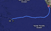
We also use the chart plotter/GPS to navigate - essentially an electronic version of the paper chart.
The GPS interfaces with the chart plotter and indicates Junk’s position, as a black triangular shape on the screen. We use the chart to avoid hazards - islands, rocks or shoals with breaking waves. As the saying goes “The ocean is not that dangerous, it’s the hard parts around the edges that will get ya”.
The chart plotter shows our Latitude and longitude, our Course Over Ground (COG), and our Speed Over Ground (SOG). While sailing, we can experiment with different sail trimming configurations, comparing COG and SOG to monitor improvements.
The charter plotter also allows us to pick a waypoint to assess our bearing and remaining distance, and acts as the screen for our AIS system.
In short, extremely helpful tools. Read more!